Another Way of Testing Your ADS-B
By Patrick Gilligan, Board Member, EAA Canadian Council
March 2020 - Another way of testing your ADS-B is by downloading the free app FlightRadar24; if you wish not to have advertisements, you can subscribe at a low cost. Other similar flight-tracking apps are also available.
FlightRadar24 will identify your ADS-B equipped aircraft; however, it will take a few flights before it will tag your aircraft with your registration letters and with an appropriate depiction.
FlightRadar24 collects data from more than one source, such as: ADS-B, SB-ADS-B, MLAT, FLARM, U.S./Canada radar, and aircraft position trend estimations up to 240 minutes. ADS-B and SB-ADS-B (SB meaning space-based) are the ones we are aware of.
MLAT is a navigation and surveillance technique based on measurement of the time of arrival of energy waves having a known propagation speed used by ATC. FLARM is used by more and more gliders so pilots can see each other while circling in thermals. Used in Europe, Canada, and the U.S., it's also known as Power-FLARM. In my case, this is very useful, as I have a large glider club within 4 nm of my aerodrome base.
U.S./Canada radar is self-explanatory. And aircraft position trend estimations are not very reliable but can be useful in some cases.
Using Stratus/Foreflight, the ADS-B In picks up traffic information service broadcast (TIS-B) and flight information service broadcast (FIS-B), including the weather and NOTAMs.
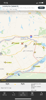
This screen capture shows a red aircraft depiction at 850 feet, flying southeast at 56 knots. The registration C-ILQK is the Borey AULA climbing out of Hawkesbury East Ontario Breakfast Fly-In.
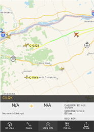
This shot shows red aircraft depiction at 1,173 feet, flying 56 knots but heading north. I wanted to know how fast my change of direction would be retransmitted to my in-flight cellphone. Time was approximately 20 seconds.
Also, both photos show my flight path, but the trail line is yellow in one shot and the other line is green. Apparently, if I was below 100 meters, the trail would have been white. Yellow is the first colour after white, then with increasing altitude green up to 2,500 meters, then light blue, and so on, up to red at the highest altitudes.
