Stratux ADS-B—One More Update
By Ian Brown, Editor, 657159
July 2016 - Although I’d been told not to expect anything in Canadian airspace out of the Stratux kit I bought over the winter, it seems we do indeed see quite a lot. Flying several times recently 30-50 nm north of the U.S. border I was able to see both weather and traffic. In fact, the weather I was seeing was exactly the same as the precipitation I was witnessing off my left wing. Seeing how far ahead it extended gave me useful information in planning a detour. The source of this weather is NEXRAD, and the towers (in the United States) broadcast a 250 km radius, so it seems to depend on how close to the border the in-range towers are located.
I saw traffic targets clearly in Canadian airspace too. Not having flown with traffic indication before, I’d have to say it’s a bit distracting for a solo pilot who should be looking out of the windshield, but all knowledge is good as long as it is used wisely. I was unsure of the symbology of traffic, so I took the time to learn a bit. Firstly, you can set up in Foreflight to not show distracting traffic that is no threat by going into settings/ map/ overlays and choosing “hide distant traffic,” which will also suppress traffic greater than 3,500 feet above or below you. This will hide that 747 headed straight for your location, but so much higher that you won’t even see it. The line projected ahead of each target indicates where it will be in 60 seconds, so longer lines indicate higher speed aircraft. The altitude of the target is indicated, plus or minus, in hundreds of feet. An aircraft passing overhead 1,000 feet above you will show as +10. If available, the tail number will be displayed.
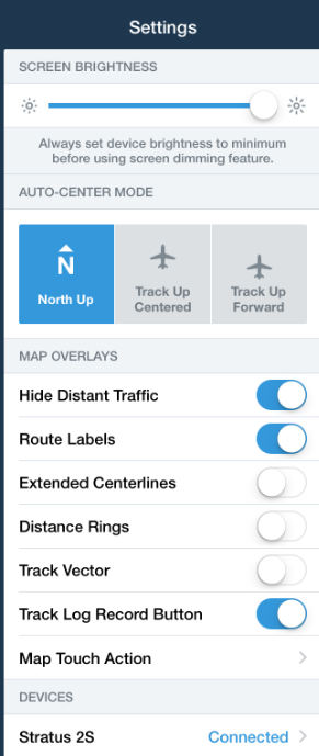
Hiding distant Foreflight traffic
Foreflight gives you a good indication of where it’s getting its data at the top left of the Maps page. In my recent case it was telling me it saw “two towers.” The legend is in white. If no towers are available, the legend is red. One recent flight was just at 3,000 feet when I was receiving good weather information. In the flight where I was seeing lots of traffic targets, I was at 7,500 feet in Ottawa’s control zone.
As Leo Nikkinen, author of last month’s excellent article on the Stratux kit, said recently, “Hey, for half the price of a tank of avgas, this is a great deal.” We’re still learning with this but I, for one, am happy to have made the purchase. Maybe a few others will join the club.
